

Since Israeli ground troops began pushing into Gaza this past weekend, it’s been hard for the world to see where they are or who they’re fighting. Many of the journalists who were inside the Gaza Strip when the war broke out are now dead. Those outside can get only distant views of a conflict unfolding not just in the northern countryside and in cities but in Hamas’s network of tunnels.
Prime Minister Benjamin Netanyahu’s stated goal is to “destroy Hamas’ governing and military capabilities” and bring home the hostages taken into Gaza on Oct. 7. No one can say with certainty how long that will take. Troops are progressing slowly as the captives’ families press for more time to negotiate their release.
The Globe and Mail has collected maps and satellite imagery to provide a rough snapshot of where the battles are happening, but there are limits to what can be verified and the situation is constantly changing. For the latest information, subscribe to updates from our full coverage of the Israel-Hamas war.

Smoke rises over the Gaza Strip, as seen from along the border with southern Israel, on Oct. 31.MENAHEM KAHANA/AFP via Getty Images
The battlefield in Gaza
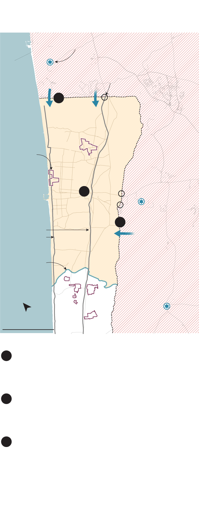
The Gaza Strip comprises about 365 square kilometres, roughly the size of Gatineau Park, north of Ottawa. Before the war, 2.3 million Palestinians lived there. After Hamas’s Oct. 7 attacks in southern Israel, which killed more than 1,400 people, the Israel Defense Forces (IDF) warned residents of northern Gaza – home to the largest population centre, Gaza City – to move south before the ground assault. Weeks of Israeli bombardment have destroyed thousands of buildings from north to south; as of Tuesday, the Palestinian Ministry of Health in Gaza estimates that 8,525 Palestinians have been killed in the territory. Another 122 have died in clashes with Israeli security forces and settlers in the occupied West Bank.
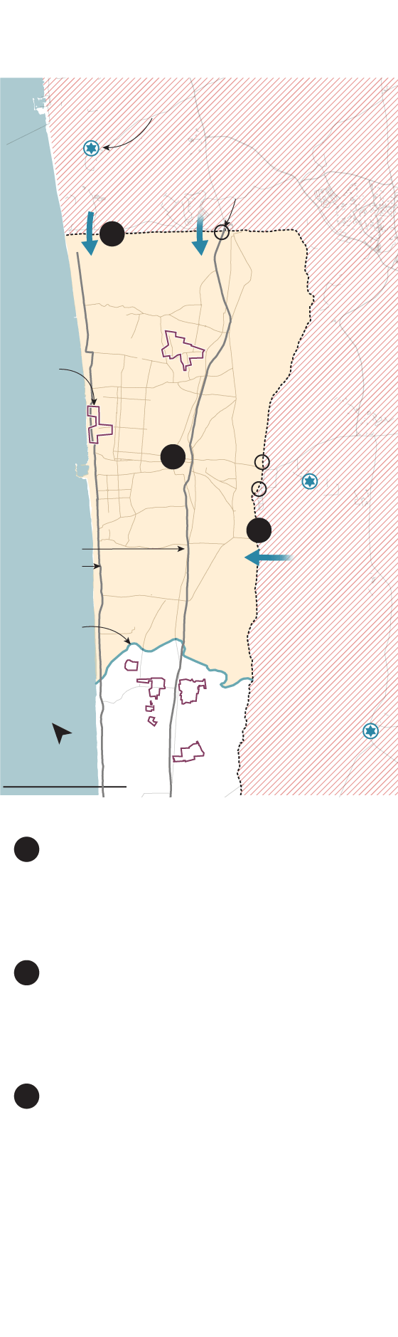
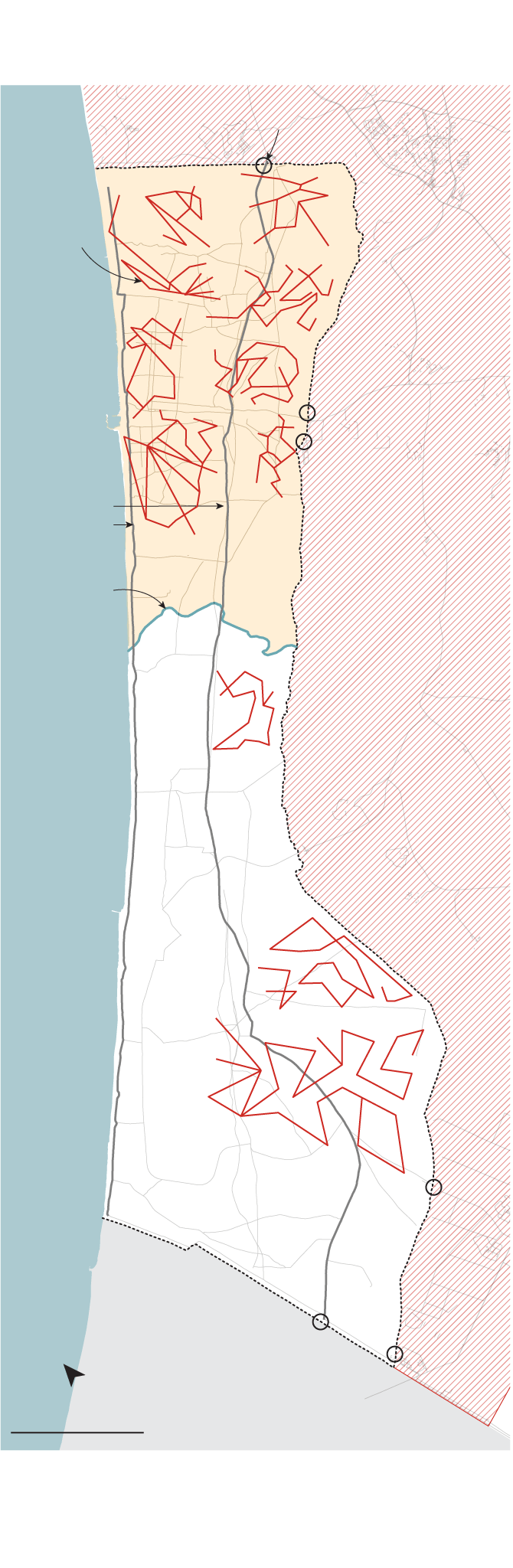
Israel-Hamas conflict
As of Oct. 31
Military base
Zikim
ISRAEL
Reported Israeli ground incursions
Border crossing
Sderot
1
GAZA
STRIP
Closed
military
zone
Jabalia camp
Refugee
camps
Beach camp
Gaza City
2
Nahal Oz
3
Main
evacuation
routes
Israeli-
ordered
evacuation
zone
Wadi Gaza
Nuseirat camp
Bureij camp
Re’im
Al-Maghazi camp
North
5 KM
1
Slow-going attack from the north
Backed by helicopters and drones, dozens of tanks and armoured personnel carriers have pushed into the semi-rural area to the north of Gaza City but have proceeded slowly.
Continued bombardment of Gaza
On Saturday, Israeli PM Benjamin Netanyahu vowed to "destroy the enemy above ground and below ground" but stopped short of calling the ground incursion a full-scale invasion.
Cutting off Gaza City from the south
Although the military has refused to say exactly where troops are operating, images on social media appear to show Israeli tanks on the road south of Gaza City. This line may threaten Salah Ad Deen Road, the main transport artery that runs the length of the Gaza Strip. Cutting it off would effectively split Gaza in two and isolate Gaza City from the south.
2
3
THE GLOBE AND MAIL, SOURCE: REUTERS
Israel-Hamas conflict
As of Oct. 31
ISRAEL
Military base
Zikim
Reported Israeli ground incursions
Border crossing
Sderot
1
GAZA STRIP
Closed
military
zone
Jabalia camp
Refugee
camps
Beach camp
2
Gaza City
Nahal Oz
Main
evacuation
routes
3
Israeli-
ordered
evacuation
zone
Be’eri
Wadi Gaza
Nuseirat camp
Bureij camp
Re’im
North
Al-Maghazi camp
5 KM
Slow-going attack from the north
Backed by helicopters and drones, dozens of tanks and armoured personnel carriers have pushed into the semi-rural area to the north of Gaza City but have proceeded slowly.
Continued bombardment of Gaza
On Saturday, Israeli PM Benjamin Netanyahu vowed to "destroy the enemy above ground and below ground" but stopped short of calling the ground incursion a full-scale invasion.
Cutting off Gaza City from the south
Although the military has refused to say exactly where troops are operating, images on social media appear to show Israeli tanks on the road south of Gaza City. This line may threaten Salah Ad Deen Road, the main transport artery that runs the length of the Gaza Strip. Cutting it off would effectively split Gaza in two and isolate Gaza City from the south.
1
2
3
THE GLOBE AND MAIL, SOURCE: reuters
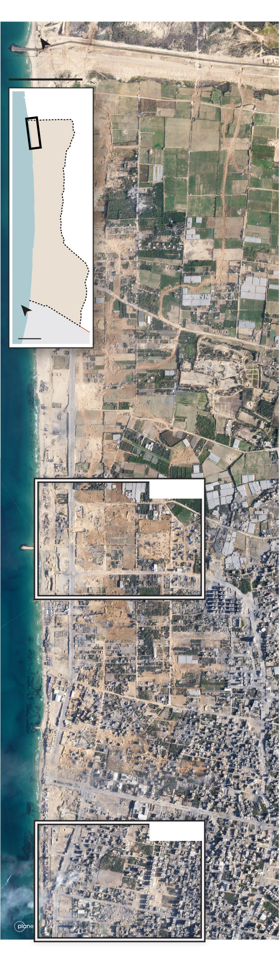
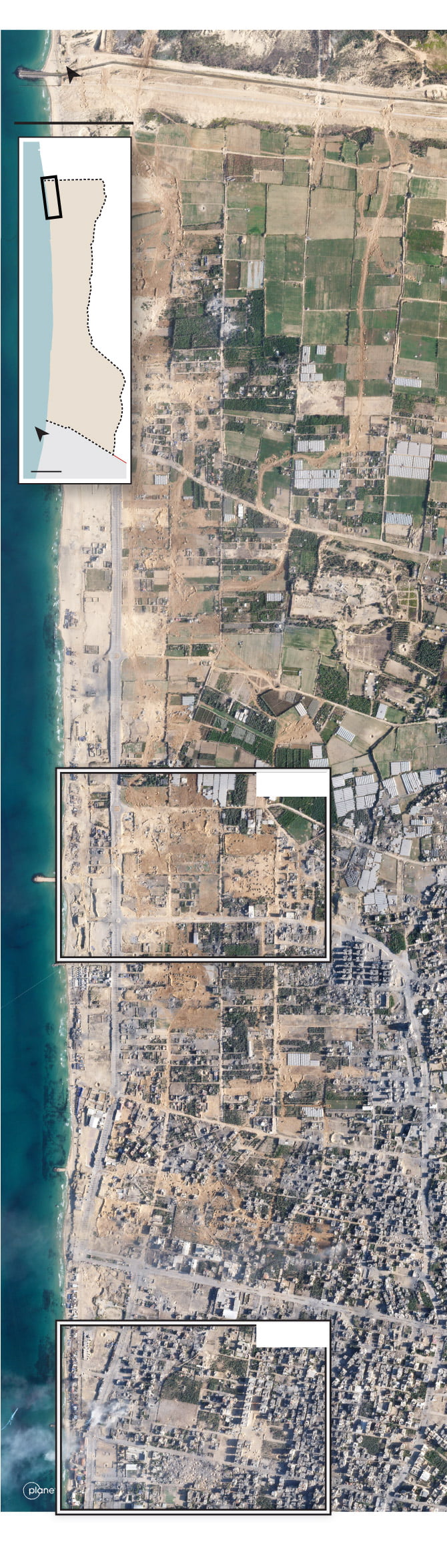
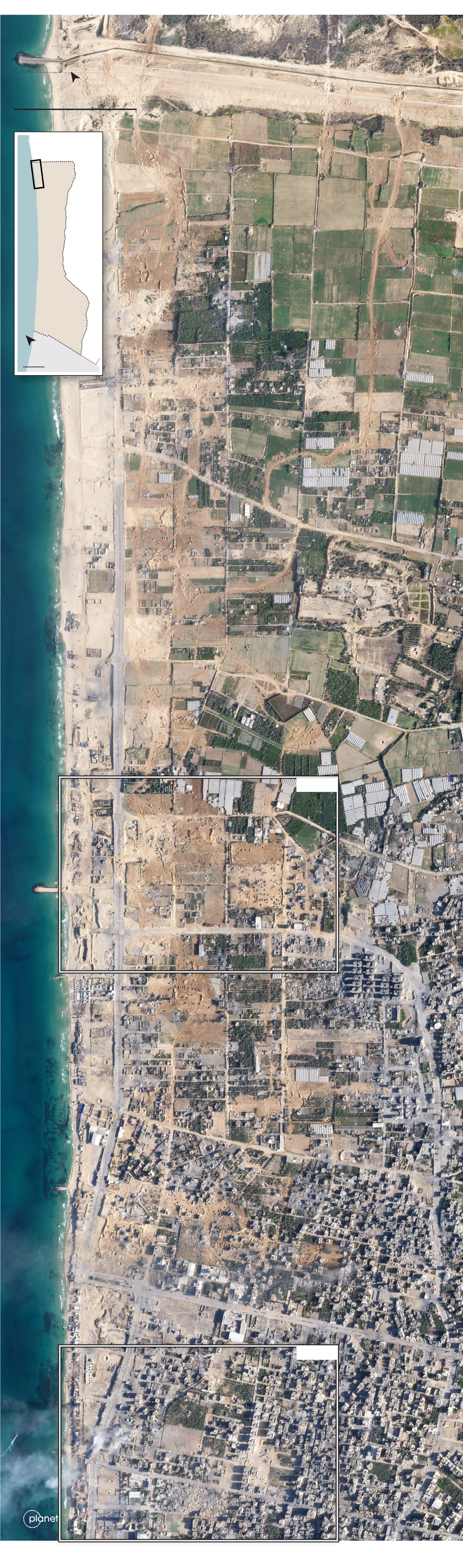
Gaza seen from space
Planet Labs PBC has been taking regular satellite snapshots of the war zone, some of which capture Israeli vehicles or damage to buildings and roads. The map below, for instance, shows a view from Oct. 30. There are two excerpts from it at the top of this article, and two more highlighted in the map that include craters, tanks or armoured vehicles. Interpreting images like these is a delicate process; without on-the-ground information about the function of destroyed buildings, or the movements of vehicles and their targets, they tell only part of the story.
ISRAEL
North
GAZA STRIP
500 m
ISRAEL
Detail
GAZA
STRIP
North
5KM
IMAGE 1
IMAGE 2
THE GLOBE AND MAIL, SOURCE: planet.com
ISRAEL
GAZA STRIP
North
500 m
ISRAEL
Detail
GAZA
STRIP
North
5KM
IMAGE 1
IMAGE 2
THE GLOBE AND MAIL, SOURCE: planet.com
ISRAEL
GAZA STRIP
North
500 m
ISRAEL
Detail
GAZA
STRIP
North
5KM
IMAGE 1
IMAGE 2
THE GLOBE AND MAIL, SOURCE: planet.com
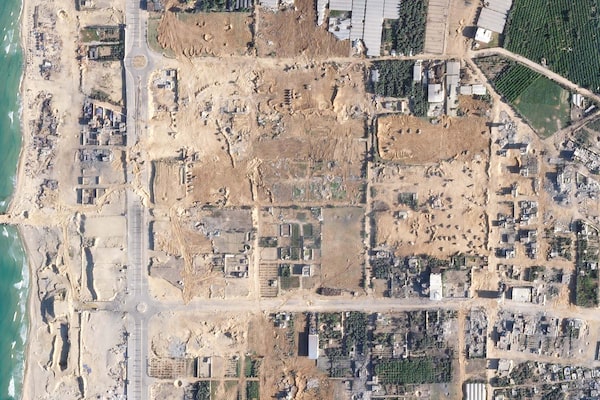
Image 1 shows a large number of Israeli vehicles and tracks they left in the dust.
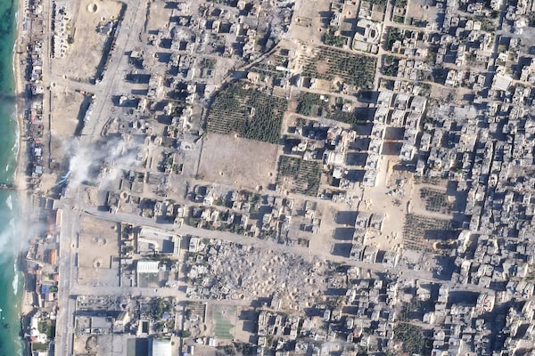
Image 2 shows a large cluster of craters in the bottom middle.
The war underground
Over the years, Hamas has excavated tunnels that Israeli troops describe as an underground city, with command centres, rocket-launching sites and storage areas. The IDF said Tuesday that it had recently fired on militants at compounds inside the tunnels; previously, it has described clashes at tunnel entrances, including one near the Erez Crossing.
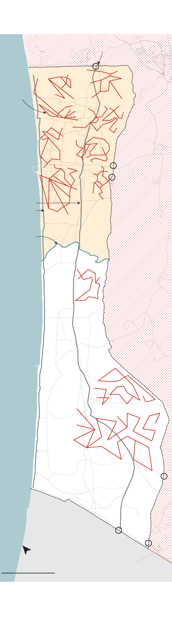
Hamas’ tunnels in the Gaza Strip
Border crossing
ISRAEL
Sderot
GAZA
STRIP
Closed
military
zone
Tunnels
Gaza
City
Nahal Oz
Main
evacuation
routes
Israeli-
ordered
evacuation
zone
Wadi Gaza
Re’im
Kisufim
Khan Younis
Rafah
EGYPT
North
5 KM
MURAT YÜKSELIR / THE GLOBE AND MAIL, SOURCE: OPENSTREETMAPS; GRAPHIC NEWS; The Humanitarian Data Exchange
Hamas’ tunnels in the Gaza Strip
Border crossing
ISRAEL
Sderot
GAZA
STRIP
Closed
military
zone
Tunnels
Gaza
City
Nahal Oz
Main
evacuation
routes
Israeli-
ordered
evacuation
zone
Be’eri
Wadi Gaza
Re’im
Kisufim
Khan Younis
Sufa
Rafah
EGYPT
North
5 KM
MURAT YÜKSELIR / THE GLOBE AND MAIL, SOURCE: OPENSTREETMAPS; GRAPHIC NEWS; The Humanitarian Data Exchange
Hamas’ tunnels in the Gaza Strip
Border crossing
ISRAEL
Sderot
GAZA
STRIP
Tunnels
Closed
military
zone
Gaza City
Nahal Oz
Main
evacuation
routes
Israeli-
ordered
evacuation
zone
Be’eri
Wadi Gaza
Re’im
Kisufim
Khan Younis
Sufa
Rafah
EGYPT
North
5 KM
MURAT YÜKSELIR / THE GLOBE AND MAIL, SOURCE: OPENSTREETMAPS; GRAPHIC NEWS; The Humanitarian Data Exchange
What would combat look like inside the cramped tunnel network? A Reuters video crew got a rough idea in 2014 when they were driven blindfolded to a secret location for this tour by masked members of Hamas’s armed wing, the al-Qassam Brigades.
With reports from Reuters and Associated Press
Israel-Hamas war: More from The Globe and Mail
The Decibel podcast
This episode of The Decibel features civilians in Gaza and Israel, and emergency workers seeking to help them, describing their experience of the war thus far. Subscribe for more episodes.
From our foreign correspondents
Former Israeli PM says foreign troops should help stabilize Gaza after war
In Cyprus, Canadian soldiers await potential orders for evacuation of citizens in Lebanon
In Israel, survivors of Hamas massacre grapple with new realities and traumatic memories
From standards editor Sandra E. Martin
Understanding the guidance behind The Globe’s war coverage
Why that photo you saw on social media may not be published in The Globe